The 1912 Balance of Power in Central Europe

IMG_1088
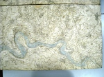
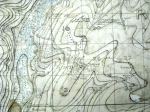
This map was found in the 1912 files of the Directorate of Military Operations, a part of the War Office, and shows how Henry Wilson and his staff saw the struggle for overall power. Apart from the obvious colour coding which shows both the Central Powers and the Triple Entente allying against each other – it also illustrates the degree to which Britain was unprepared for war on a continental stage. The six division Expeditionary Force that was envisaged could do little other than play a subsidiary role next to the sixty-six French divisions that would line up along the Western Front.

Of far greater importance was the political significance of the BEF’s involvement which had been summed up in the following conversation between Wilson and Foch in 1909:

Wilson: “What would you say was the smallest British military force that would be of any practical assistance to you in the event of such a contest as we have been considering?”

Foch: “One single private soldier and we would take good care that he was killed.”

Great War Sites in the UK

A listing of the extant Great War sites that can be found around the UK. If you would like a site added to the map, please leave a comment below or contact me with the details.

https://briancurragh.wordpress.com/great-war-sites-in-the-uk/

This is the result of a small mapping project that started back in 2009 in a discussion thread on the Great War Forum. The original concept was to collate extant Great War sites within the UK and provide a resource that would be useful when visiting an area but could also help with the recording and preservation of the sites.

Thanks to David Faulder from the Great War Forum, who introduced me to the possibilities of Google Maps and set the initial map up, and the Western Front Association who have placed the map on the Maps page of their website.

The Maps, Plans & Drawings collection of Military Barracks in Ireland

The Defence Forces Ireland have started to make their archives available online on their website – http://www.militaryarchives.ie/home – with two areas released to date: The Bureau of Military History & The Maps, Plans and Drawings collection of Military Barracks in Ireland.

The Irish Military Barracks Maps, Plans and Drawings Collection is described as “a unique collection pertaining to the construction and maintenance of military barracks in Ireland from c.1830 to c 1980” and “contains many previously unseen architectural drawings from the British War Office, the Royal Engineer Corps, the Ordnance Survey and latterly the (Irish) Defence Forces Engineer Corps.” Of their collection of 4,000 maps and drawings, 650 have been released online already.

From a Great War point of view, there are several gems hidden within the collection, three of which are highlighted here.

Clandeboye Camp, Down, Ireland

This plan is dated 5th May 1915 and captures the layout of the camp right before the 36th (Ulster) Division vacated the camp on its way to Seaford in Sussex before embarking for France in October 1915.

Ballykinler Camp, Down Ireland


The other two plans show Ballykinler Camp – the overall map is dated 1903 while the plan of the camp layout is from 1919. Ballykinler was also used by the 36th (Ulster) Division for training before becoming an internment camp initially during the Irish War of Independence, this use continuing after partition in 1921.

For any researcher looking into the activities of the British Army in Ireland, the online archive can be highly recommended.

Douglas Haig Map Cabinet, Sandhurst

A great privilege to be at the unveiling yesterday of the Haig Map Cabinet at The Royal Military Academy Sandhurst. The cabinet was found in a storeroom at Duxford ten years ago – and it has taken since then to complete their conservation.

The 108 relief maps are made of cardboard layers, with a 4.5 vertical exaggeration factor that follow the trench maps’ contour lines, were made by a department with in the Ordnance Survey that was set up in December 1916. The maps used are principally 1917 versions although a few are 1918 in origin. In addition to the main set there are six later maps that interestingly cover the terrain beyond the Ypres Salient and indicate possible areas for the hoped for exploitation.

The relief maps are mentioned twice in Haig’s diary – the entry for Tuesday, 2nd August 1917 reads:

“At 10pm I saw Gough and Malcolm with Kiggell. I showed him on my relief map the importance of the Broodseinde-Passchendaele ridge and gave it as my opinion that his main effort must be devoted to capturing it”.

The maps do clearly illustrate that Haig & GHQ were not ignorant of the task ahead and well aware of the importance of understanding the terrain to be taken.